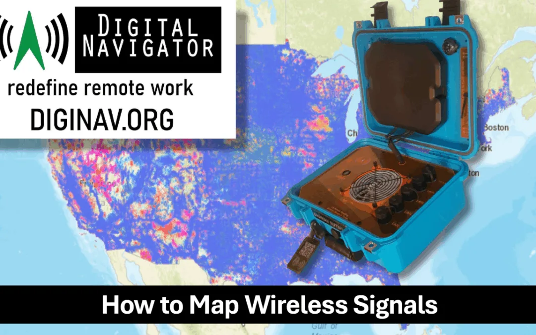
FCC Rural Cell Maps are seriously FLAWED!

Federal funding for Rural Broadband is huge! The problem is the data the FCC uses is deeply flawed. They base their funding on data provided by the carriers, who have no motivation to reveal their true coverage areas. Worse still is their decisions are based on download speeds which is a very limited reflection on consumers true cellular quality of service.
Here is the actual disclaimer off the DCC official website!
FCC DISCLAIMER
Mobile providers generate the 3G, 4G LTE, and 5G-NR coverage areas shown on the map using propagation modeling, where the models include certain common settings for consistency. The coverage areas are meant to represent the areas where a user should be able to establish a mobile connection, either outdoors or moving in a vehicle, and achieve certain upload and download speeds. Please note that the map does not include information on the availability of mobile wireless broadband service while indoors. Moreover, because the coverage map is based on propagation modeling, a user’s actual, on-the-ground experience may vary due to factors such as the end-user device used to connect to the network, cell site capacity, and terrain. The coverage maps on mobile wireless service providers’ websites may be based on different parameters and assumptions, such as service availability provided through roaming agreements, and therefore may differ from the information shown here.

Problems with the FCC cellular data
- Data provided by carriers, not independent survey
- Propagation maps are theoretical
- Maps based on download speeds only
- Standard speed measured is 5 mbps down, 1 mbps up.
- Wireless data usage has exploded
- Lower income households may only have phone or tablet as primary computer.
- Time of day not attributed
- Weather not factored
- No standard for measurement
- Data difficult to use in comparative analysis
The Solution is BYOND


While the FCC map only shows download speeds, our BYOND system records so much more critical information for decision makers.
TIME:
- The time and date of the data collected.
GPS LOCATION:
- Location that the signals were collected.
Carrier:
- A cellular carrier, also known as a mobile network operator (MNO) or wireless service provider, is a company that provides wireless communication services to customers.
Cellular Band:
- Also known as a frequency band, bands are specific ranges of electromagnetic frequencies allocated by regulatory bodies for cellular communication. Different cellular bands are used to support various types of wireless communication technologies, including 2G, 3G, 4G LTE, and 5G.
- Bands are often identified by numbers. For example, LTE Band 1 corresponds to 2100 MHz, Band 3 to 1800 MHz, and so on. In 5G, bands are similarly numbered, like n78 (3.5 GHz) and n41 (2.5 GHz).
RSRP (Reference Signal Received Power):
- Measures the power of the received reference signal in LTE networks.
- Typically ranges from -44 dBm (excellent) to -140 dBm (poor).
- Important for determining the signal strength from a cell tower.
RSRQ (Reference Signal Received Quality):
- Indicates the quality of the received reference signal.
- Typically ranges from -3 dB (excellent) to -19.5 dB (poor).
- Helps evaluate the signal quality in terms of interference and noise.
SINR (Signal-to-Interference-plus-Noise Ratio):
- Measures the quality of the signal in comparison to the level ofinterference and noise.
- Typically ranges from -20 dB (poor) to 30 dB (excellent).
- Higher values indicate better signal quality and less interference.
RSSI (Received Signal Strength Indicator):
- Measures the total received power, including both the desired signal andbackground noise.
- Typically ranges from -50 dBm (excellent) to -120 dBm (poor).
- Useful for understanding overall signal strength but less precise thanRSRP for LTE networks.
Cell ID:
- Identifies the specific cell tower and sector serving the device.
- Useful for network troubleshooting and optimization.
MNC (Mobile Network Code) and MCC (Mobile Country Code):
- Identify the specific mobile network and country of operation.
- Useful for ensuring correct network identification and operation.
ECIO (Energy per Chip per Interference):
- ECIO is a critical parameter that indicates the quality of the received signal by measuring the ratio of the received signal energy per chip to the interference level.
- A high ECIO value indicates good signal quality, which can lead to higher data rates and better overall performance. Low ECIO values suggest poor signal quality, which can result in dropped calls, lower data rates, and poor voice quality.
- Good Signal Quality: ECIO values typically range from -5 dB to -10 dB.
SINR 5G (Signal-to-Interference-plus-Noise Ratio 5G):
- Signal Quality: SINR directly impacts the quality and reliability of the wireless communication link. Higher SINR values indicate better signal quality, leading to more reliable connections and higher data rates.
- Throughput and Capacity: SINR affects the throughput and capacity of the network. Higher SINR allows for higher-order modulation schemes and more efficient use of the available spectrum, increasing the overall capacity of the network.
RSSI 5G (Received Signal Strength Indicator 5G):
- RSSI in the context of 5G networks is a measure of the power level that a mobile device receives from the cellular network.
- It is an important metric for determining the strength of the received signal and is used in both LTE and 5G NR (New Radio) technologies.
RSRP 5G (Reference Signal Received Power)
- RSRP is the linear average over the power contributions (in watts) of the resource elements that carry cell-specific reference signals within the considered measurement frequency bandwidth.
- It represents the average power level of reference signals received from a single cell by a user equipment (UE) device.
- Serves as a measure of the received signal strength and is used by the network and user devices to make decisions about cell selection, reselection, and handover.

Police, Fire and Ambulance Radios
Cradlepoint radios in usewith existing emergencymanagement vehicles canbe easily modified withsoftware to provideadditional signal sensors fora more granular communitywireless signal survey.
After the survey there are multiple uses for the case
Connectivity for Remote Locations

- Pop-Up Clinics: Provide connectivity for health services or vaccination drives.
- Remote Workstations: Enable local government employees to work in temporary or offsite locations.
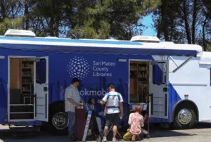
Mobile Operations
- Rural Outreach: Deploy internet services in underserved or rural communities during specific initiatives.
- Mobile Libraries: Provide internet access for educational programs or mobile library units.
Events and Public Gatherings
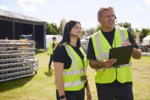
- Temporary Wi-Fi: Offer internet at public events, festivals, orcommunity meetings.
- Event Coordination: Ensure staff, vendors, and volunteers remain connected.
Mobile Operations
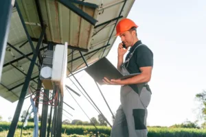
- Field Inspections: Support connectivity for inspectors using digital devices in the field.
- Utility Work: Provide a network for teams repairing infrastructure.
Public Safety and Law Enforcement
 Surveillance: Support cameras and monitoring equipment at crime scenes or public events.
Traffic Control: Provide network access to traffic management systems, such as mobile signs or temporary traffic lights.
Emergency Response
 Disaster Recovery: Establish temporary internet and communication channels in disaster-hit areas.
Incident Command Centers: Enable communication and coordination in pop-up or mobile command centers.
